The Celts
Sometime during the period between 1365BC and 976BC a timber causeway construction was erected by the indigenous Fen people. Using over 1,000,000 timbers it lay buried in the marshy, fen soil to the east of the present City. The archaeological site of Flag Fen is situated to the east of today’s City. It connected ‘Whittlesey Island’ to the ‘Peterborough’ Neolithic and later Bonze and Iron Age Settlements across the wet Fenlands.
There was great environmental changes happening during this period and the land began to get much wetter. The land was about a meter lower than todays levels. It is thought the Causeway was also used as a religious platform where people came to make offerings to the Gods. Probably to ask for their homes and farmsteads to be protected from the environmental changes. Many artifacts have been retrieved from the excavations of the causeway in Flag Fen.
Around 700 BC the Celts crossed from Europe bringing with them Iron Ore Extraction, their language and an introduction to gold, silver and bronze as coinage and jewelry, although most trade at this time was conducted by barter. The Celts called Britain the Pretanic Islands, which evolved into the modern word Britain.
Around this time a settlement was known to be in existence somewhere between Westwood and Spital Bridge. A natural spring water stream that became a tributary to the Nene, and much later called Tom Lockes Spring, originated near Westwood Bridge continued to Spital Bridge and then following along what is now Long Causeway (boats were moored along this stretch) through what is now Cathedral Square and on to the River Nene.
Small agricultural settlements continued to thrive in and around the Fens until the Roman’s first expedition in 54 BC then the invasion in 43AD.
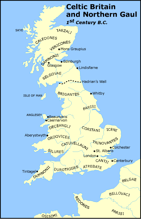
This is a map is a reconstruction of the Greek, Potolemy’s, map of the Celtic tribes of Britain. The original was drawn in about 150AD.
It’s not really clear what tribe the people of the Fens fell into. People of this area were on the western edge of the Iceni Tribe and the northern edge of the Catuvellaundi Tribe. I suspect the Fenlanders secure in in their dangerous watery habitats were very much their own people.
The Romans.
After the Roman invasion of England, most of the Iron Age tribes in the South of the country accepted the Roman lifestyle, and were generally peaceful. However, the Iceni the tribe based in East Anglia and the Fens, were not so peaceful and the Roman had the need to build Military Forts near Water Newton and another at Longthorpe in order to guard crossings of the River Nene at those positions. The Longthorpe Fort (found in the Nene Valley under what is now the Western edge of the Thorpe Golf course) was built to house half a Legion, around 3000 soldiers. The first mention of a Military presence at Water Newton was in AD43. Some 17 years later units of the infamous Roman Ninth Legion, based at Longthorpe were massacred by local Iceni warriors.
The great Roman road of Ermine Street (it eventually became the Great North Road and now the A1) was constructed between London and York and passed through Durobrivae, Another Roman road ran eastwards through the Fens called the Fen Causeway. It was actually was built over the now buried Bronze Age Flag Fen Causeway site and the foundations of this road can now be seen at the Flag Fen archaeological site.
The Roman town of Durobrivae grew up in the Nene Valley around the Military Garrison. This was close to the presence day small village of Water Newton, close to Chesterton and Alwalton (on the A1 just west of Peterborough) Durobrivae was also to become one of the richest Roman towns due to its flourishing pottery industry. It’s importance was such that it has been suggested that Durobrivae was probably a regional capital and market centre.
Due to the prosperity of Durobrivae, Roman Villas sprung up all over the area. One in particular, a Pretorium (or Praetorium, a large palace like building) at Castor, was mistaken for a small village when it was first discovered, and has turned out to be the second largest Roman building ever found in this country. There was even a Temple here, which stood where Castor Junior school stands today. The current church of St Kyneburgha at Castor stands in what was the courtyard of this Pretorium. A section of Roman wall can still be seen in the wall surrounding the garden of the old Vicarage.
The Roman rule continued for 400 years. Paganism and Christianity existed side by side until 379 AD when a decree stated worship of all Heathen Gods was decreed illegal. The spread of Christianity was hindered after the Roman withdrawal and the invasion of the Jutes in 499 and the Saxons in 475. There followed some 600 years of saxon rule. Reconversion to Christianity began once more in 597 AD with the arrival of St Augustine from Rome who introduced the Benedictine Order of Monks to Britiain. They were to build many Abbeys in the country, including the one in Medehamstede, now Peterborough.
The Saxons
Medehamstede, was the name given to a village built by the Saxons, It means Meadow Homestead, another meaning is given as The home by a deep well. Medehampstede was in the Kingdom of Mercia. One of the severn Saxon Kingdoms. It’s King was Penda and his son Peada married into a Christian family. A mission of Benedictine monks came to this area and in 655AD, a monk, known as Saxulf, founded a monastery on the solid ground that is now where the Cathedral is standing. The Abbey was abandoned around the year 870AD when the Danes, or Vikings, were invading and plundering the area. Some years later a new Benedictine Abbey was built between 960 and 970AD. A wall around the settlement was built to protect themselves against further attacks from the Danes.
Having fortified the settlement, the place then was called St. Peters Burgh. Soon, a market was built, and the city continued to prosper and grew to become a small town.
The Normans
However, in 1070AD, an army of Danes, together with some Saxons, attempted to overthrow William the Conqueror, in the process, attacking and burning down Peterborough. William the Conqueror appointed Abbot Thorold who built a Garrison, Tout Hill, to protect the Abbey. During the Dark Ages, Peterborough was under the rule of the Abbots, making it a humble and trivial town at the time. Fire attacked the city again, but just like before, the City got by and began to rebuild again. One fire broke out in a bakehouse setting light to the Church and town and it is said the Abbey tower burnt for nine days. A second Abbey was rebuilt, in its present form, between 1118 and 1238AD.
Sometime between 1262-1273 the growing town received its Town Charter.
The Abbey of Peterborough was Sacked just again in 1539, by Henry VII, but, as his first wife Katherine of Aragon was buried here in the Abbey it wasn’t totally destroyed The Abbey became the Cathedral of the new Diocese of Peterborough in 1541 and it is now known as the Cathedral Church of St Peter, St Paul and St Andrew. The city's population now increased to 1500 people, making Peterborough a small yet official city.


No comments:
Post a Comment